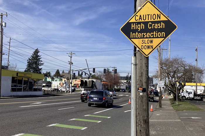
A man driving a gray Toyota pickup truck seems frantic; veering in and out of lanes trying to pass other traffic on the Interstate Bridge. His furtive moves don't do him much good—moments later, as we crest the green steel bridge headed south into Portland, we're greeted with flickering brake lights. Traffic slows to a plodding 20 miles an hour. We've stumbled into the morning congestion, a daily feature of the Vancouver-to-Portland commute.
Fortunately, it's a commute I never have to make. I drove to Vancouver on a recent morning to guide my Oregon-plated car into the current of vehicles bearing Washington plates purely as an experiment. I spent twice as much time in the southbound lanes trying to return to Portland as I had in the northbound lanes venturing into Vancouver. My blood pressure rose. I cursed OPB's April Baer for reminding me about the traffic I was clearly stuck in.
Like me that day, the vast majority of people driving across the bridge each morning—and back across each evening—are coming from Vancouver. According to 2005 numbers, 64 percent of people crossing the bridge southbound hopped onto I-5 via one of Vancouver's on ramps. Northbound, 60 percent of vehicles jump off the freeway into Vancouver. Unsurprisingly, Vancouver—with its cheaper real estate—is functioning as a bedroom community to Portland. And unsurprisingly, those commuters would like an easier commute into Portland.
One answer may be on the way, in the form of a $4.2 billion, 12-lane replacement bridge, coupled with light rail or bus rapid transit, and smoother on and off ramps in the five miles surrounding the bridge. Traffic engineers say the new bridge across the Columbia River—AKA the Columbia River Crossing—will make travel between the two states easier, safer, and faster.
It's the biggest public works project in our region's history, it's been years in the making, and local government bodies are poised to make final decisions on the project in the next few months. The problem is, even if we build one of the proposed new bridges, traffic is still going to increase from today's levels. And in an era of climate change—when a state task force has recommended drastically cutting greenhouse gas emissions to 75 percent below 1990 levels—increasing lanes and thereby increasing commuter traffic is simply unacceptable.
A Recipe for Disaster
Nearly everyone agrees that the bridge and the five miles of freeway surrounding it are trouble spots. Columbia River Crossing graphs show that current collision rates are proportional to traffic volumes, but "appear to increase two-fold" during peak congestion. Short entrance and exit lanes give drivers little room to maneuver into a through lane. The bridge lifts about once a day to allow river traffic to pass underneath, and "three to four times more collisions occur" on the bridge during a lift, when traffic is stopped. (The bridge has the only red light on I-5 between Mexico and Canada, too.) Transit options are limited, carrying an average of only 3,475 people across the bridge each day. Clearly, the crossing could be improved.
In 2001, Oregon and Washington agreed. The "Transportation and Trade" partnership recommended coming up with solutions to congestion in three spots, including the bridge over the Columbia.
In 2005, the Columbia River Crossing project was born. By last spring, the 39-member Columbia River Crossing (CRC) task force narrowed down the possible solutions to five that address the area's problems: "congestion, dangerous travel conditions, and travel demand that exceeds capacity," according to a CRC summary. The options include both a 10-to 12-lane replacement bridge and a four-to five-lane supplemental bridge that would augment the existing span, which would be downsized to four lanes. Both of those options are being studied twice: once with light rail, and once with bus rapid transit. The fifth option is a "no build" option that compares the alternatives to doing nothing.
A Draft Environmental Impact Statement (DEIS) analyzing those five options will be released sometime this month. From there, the public can weigh in for 60 days, and the local jurisdictions—including the City of Portland and Metro—will vote on the "locally preferred alternative" chosen by the CRC task force. Once the agencies agree on an alternative, the project will be submitted for federal funding, with the goal of starting construction in 2010.
The DEIS isn't out yet, but there's already data on the five alternatives—and the numbers don't look too good.
Right now, 134,000 vehicles cross the bridge in a given day.
If we do nothing—absolutely nothing—that traffic is going to increase thanks to growth in the region, causing many more hours of congestion. By 2030, CRC staff estimate, 184,000 vehicles will use the I-5 bridges daily, a 34 percent increase from today's levels, and they'll be stuck in eight hours of northbound congestion, and seven hours of southbound congestion. In other words, that section of freeway will be clogged up just about all day.
But if a replacement bridge is built, paired with high-capacity transit like light rail, and tolled, traffic in 2030 will be only 178,000 vehicles a day. That's a decrease, project staffers argue, if you compare it to 2030 traffic without a new bridge, transit, and tolls. Indeed, according to their math, the $4.2 billion project gives us a three percent reduction in traffic—compared with sitting around and doing nothing.
But according to the project staff's own numbers, it's light rail and tolls that has the biggest impact on the traffic in 2030, reducing it by a whopping 20 percent. CRC staff compared a new bridge with transit and tolls to a new bridge without transit and tolls. Without the alternatives and fees, roughly 225,000 vehicles would use the bridges in 2030. With them, 2030 traffic is cut by one-fifth—to the 178,000 figure.
The problem is, no one has bothered to study what happens if we do the things that deter people from crossing the bridge in the first place. Ideas that would give commuters an alternative, but don't make driving an easier choice. In other words, could we reduce traffic by 20 percent today by building light rail to Vancouver, and tolling the bridge now, without spending billions of dollars on a new, bigger bridge? Instead of giving Vancouver drivers a continued excuse to drive their single-occupancy vehicle into Oregon every day, why not give them reasons to leave the car at home?
But that option's not on the table. What the hell are we thinking?
Climate Change Is Coming
According to the final report of Governor Ted Kulongoski's Climate Change Integration Group (CCIG), released in January, Oregon needs to "act now" to address the threat of global warming.
If we don't, the prognosis is grim.
"A broad scientific consensus tells us that climate change is accelerating, and that it is happening at a speed that was unanticipated even recently," the CCIG report says. "It is urgent that we act now, both to reduce the cause of this earth-transforming crisis by rapidly driving toward a low-carbon economy, and to begin to prepare for and adapt to the changes that mitigation cannot prevent."
The CCIG report doesn't mince words in describing Oregon's future, if we don't make drastic changes. "Sea-level rise is likely to erode beaches, flood low-lying areas, and increase the damage during storm surges. Changes in average growing season temperature will change the types of wine varietals that may be grown in Oregon, making some areas suitable for wine growing that presently only support less valuable crops, while making some high value wine grapes such as pinot noir more difficult to grow. Changes in climate will affect public health, as patterns of communicable diseases and disease vectors in Oregon change; chronic disease risk factors like ambient pollen concentrations, the prevalence of smoke from forest fires and physical activity patterns are altered; and economic changes threaten communities and put some Oregonians at risk for family violence and suicide." In other words, we're all going to die (and drink bad wine in the process).
Thankfully, the CCIG came up with a plan. It's not an easy one, however. According to the group's calculations, "we must reduce emissions by 42 percent from forecasted business-as-usual levels."
The "Oregon Strategy"—a 2004 report recommending greenhouse gas reductions, which the state legislature adopted last year—dictated a similarly tough goal: Emissions need to drop significantly, to at least 75 percent below 1990 levels, by 2050. Considering that we're currently pumping out emissions at a level that's 22 percent higher than 1990 levels—and we're expecting considerable population growth in the near future—we've got a lot of work to do.
According to the Oregon Department of Energy, transportation is the single largest source of greenhouse gas emissions in Oregon, accounting for 34 percent of emissions.
Smartly, the CCIG report devotes an entire chapter to transportation and land-use recommendations, urging the state to reduce "vehicle miles traveled." According to the report, "it is the area in which the state can have the most influence." Moreover, "reducing [vehicle miles traveled] is simply the single most effective way to reduce greenhouse gas emissions."
Though the report doesn't specifically address the CRC project, the general recommendations caution against expanding infrastructure—which is exactly what the CRC project, which began before either report was issued, is poised to do.
"Traditionally, improvements in transportation systems have focused on supply, increasing capacity to meet travelers' needs. However, new infrastructure is expensive and may induce demand, locking governments into a spending cycle of adding increasingly more capacity as more drivers take advantage of new facilities."
Opposition Mounts
Last October, Sightline, an environmental think-tank based in Seattle and focused on the Northwest, released a study addressing highway expansions' impact on emissions. Not surprisingly, Sightline found that building more roads increases greenhouse gas emissions, even when improved fuel efficiency of future vehicles is taken into account, and even if the highway expansion project initially relieves congestion (cars that aren't idling in stop-and-go traffic pollute less).
"Sightline assumes that rush-hour traffic will flow more freely after new lanes are opened, and that congestion relief will raise the effective fuel efficiency of vehicles on the roadway," wrote Sightline's Clark Williams-Derry. "However, consistent with academic findings and real-world experience, we also assume that new highway capacity in a metropolitan area will gradually be filled by new trips, and that congestion and stop-and-go driving will gradually increase to approximately the same level experienced prior to the highway expansion."
Applying that logic to the CRC project—which, project staffers say, is bigger than the current bridge thanks to auxiliary lanes that allow for smoother entrances and exits—Williams-Derry points out the potential long-term effects of a bigger bridge. "You're increasing the capacity of the corridor. The end result is that there's going to be more space in the corridor and in that facility for more cars. Over the long haul, any cars that get diverted from the main freeway lanes into the auxiliary lanes, that's going to free up more space for long-distance traffic on the Columbia River Crossing."
And according to Sightline, "Adding one mile of new highway lane will increase CO2 emissions by more than 100,000 tons over 50 years." To put that in context, the average US citizen is currently responsible for 20 tons of CO emissions each year.
Groups like Sightline aren't the only ones raising alarm bells about building more roads. Locally, critics of the big bridge are emerging as the CRC project nears a decision-making point.
Joe Cortright, an economist with Impresa Consulting in Portland, released an economic analysis of the CRC project on February 13. In it, he compared the cost of the bridge project to "80 OHSU aerial trams," which "works out to nearly $2,000 per capita from each of the region's two million residents."
He picks apart the CRC's own numbers, and concludes that the bridge isn't going to solve any traffic problems. Instead, it will exacerbate congestion: "Growth in trips across the Columbia will be 70 percent greater with the bridge than if we don't build the bridge... The presence of larger transportation facilities encourages people to take trips they would otherwise avoid, or re-route."
And that traffic will spill over into the rest of the transportation system, Cortright argues. (Watch out, North and Northeast Portland.) "Presumably, with four or five travel lanes in each direction, there will be no congestion on the bridge. But what about the rest of the traffic system? How do they manage this volume without congestion on the rest of I-5? How do I-5 and North Portland road networks handle the additional 13,900 peak hour trips that will be generated by the new bridge?" Cortright asks.
The CRC's Transportation Planning/Traffic Engineering Team, along with project finance specialists, issued a March 3 memo reviewing Cortright's analysis. The CRC staffers called Cortright's analysis "incorrect," because, for example, he uses numbers from a preliminary 2002 study.
Cortright responds: "I used the newest data I could find on their website when I put it together. They've come up with some other numbers. It doesn't lead me to believe that what I wrote was wrong," he says. "What we know is—and what their data shows—that bridges cause more traffic, and tolls reduce it. It you want to reduce traffic, tolls and transit are the way to do it."
The Coalition for a Livable Future (CLF)—a group of over 90 organizations working for "healthy and sustainable communities" in our region—is pushing for a "climate smart" Columbia River Crossing. The current proposals, according to the CLF, represent an "outdated freeway expansion project that will increase global warming pollution, harm people's health, and undermine our region's vision of a sustainable economy."
Instead, the CLF wants to see a project that "reduces the growth in driving," according to Co-Director Jill Fuglister, who's also a member of the CRC task force. They recently adopted a "Climate Smart" resolution that says "we only support a Columbia River Crossing Project that will reduce the growth of driving in the future."
More Lanes, More Problems
Fortunately, the six local agencies involved in the project on both sides of the river—on this side, that's the City of Portland, Metro, and TriMet—have veto power over the project (Metro votes in April, and Portland's city council votes in May on the preferred alternative). CLF members are hoping to convince one agency to put a stop to the big bridge plan.
As that battle shapes up, local political leaders are gathering information, and beginning to take sides. At the City of Portland, Transportation Commissioner Sam Adams "really wants to hear what the community has to say on it," says his chief of staff. Mayor Tom Potter, according to a spokesperson, "has serious questions about how it's got to this point," but doesn't believe it would be a good idea "to pull back" at this time. Commissioner Dan Saltzman hasn't taken a position yet, and Commissioner Erik Sten will likely have left office by the time the issue hits the city council.
Commissioner Randy Leonard says his position has been consistent: "I would be generally supportive of the project on the condition that it has light rail, pedestrian and bike lanes."
At Metro, Councilor Robert Liberty has "very serious reservations about the project. It shows weaknesses in how we make decisions about transportation. It's a failure in creativity in how to define and address the problem."
He'd prefer to start by tolling, and then build the bike and pedestrian plus transit connection as a second phase.
So far, Liberty is the most outspoken of local leaders, but he says several of his colleagues on the Metro council— which will also consider the project—are "raising concerns."
It's unclear, however, if Liberty's strong views will trickle over to the City of Portland. "There's something basically wrong with the idea that the approach to Portland, which is trying to brand itself as a leader in sustainability, is a 12-lane bridge. How we spend our money says a lot about what kind of place we are, and I think we can do a lot better than this."